Tuesday, July 30, 2019

Petroleum Exploration- Innovation R&D- Airborne Seismic

An integrated geophysics and logistics R&D project are called METIS, Multiphysics Exploration Technology Integrated System.

METIS aims to improve the quality and speed of data acquisition through real-time quality control and processing, while at the same time slashing both the cost and HSE risks of operations.
“Tomorrow’s most promising onshore oil and gas exploration acreages are located in foothills, yet these areas have been underexplored as traditional exploration methods are not suitable to deal with these complex environments
Imagine a swarm of drones hovering over a remote tropical forest dropping what looks like large darts. The darts are actually seismic receivers delivered from the air. They are part of a project to rethink how surveys are done in remote spots where the jagged landscape limits movement on the ground.
The goal is to find ways to sharply reduce both the cost and the environmental impact of gathering the volumes of data needed to illuminate oil and gas deposits in complex, hard-to-image formations.
Rather than hacking paths through dense forests to set out lines of seismic receivers, they are building and testing a system using drones to drop thousands of receivers that will biodegrade after the survey.

A radio communication system developed by Wireless Seismic, called the Downfall Air Receiver Technology (DART) links the dropped DARTs to a control and processing center that monitors the quality of incoming data and makes changes if there are problems.

FRONTIER TECHNOLOGY

The current version of the system will be tested later this year when a single drone will be used to drop 100 of the DARTs over a 0.2-km2 area. That will show if a new carrousel on the underside of the drone, which carries four DARTS, can drop them one at a time at locations along its route.
They will also see how reliably the DARTS can record and transmit data. This will require landing them in a nearly vertical position for reliable data gathering and then transmitting the information to a central processing center.

Total is building toward an “industrial-scale” pilot project, which it hopes will be ready in 2021, to deploy 40,000 to 50,000 DARTs over a 100-km2 area.

1.dart-shaped


This dart-shaped seismic receiver picks up data and sends them to a central processing center during a seismic survey.


AIRBORNE DELIVERY


Automated drone flights carpeting the forest floor are just one of the aerial departures from conventional ground-based, data-acquisition methods.
To move in heavy loads without a road or runway, Flying Whales, to develop a new airship, called the HA2t. It is designed to be packed inside a standard shipping container for rapid delivery around the world.

2.airship


This airship, called the HA2t, can lift 2 tons into remote areas, and can be shipped in a standard cargo container.


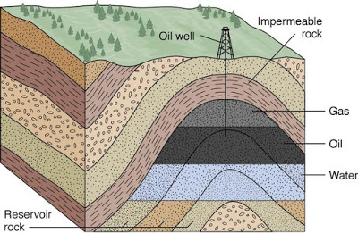
Before any heavy equipment arrives, data from satellite imaging and aircraft surveys using a variety of methods—hyperspectral, radar, and LiDAR (Light Detection and Ranging)—are used to create detailed maps of the surface and near-surface. Those will be used to choose the best locations for seismic sound sources and receivers, and plan how best to manage the operation.

3.Lidar data


LiDAR data are used to map the contours of the survey area during the planning process.


Technically speaking, good imaging of complex rock requires high trace density. That is a measure of the quality of the subsurface illumination, which is a function of the number of seismic sources and receivers. More receivers can compensate for fewer sound sources, and vice versa.
And they must be evenly distributed to ensure the entire area is covered. Adding receivers is likely to be the best option for increasing the trace density.
“By adopting a carpet receiver approach, where receiver stations are located on average 50 m in all directions, METIS reduces the dense source requirement” by using more receivers.

Credits: Oil and gas portal

Friday, July 26, 2019

Petroleum Industry | HSE – Concepts | Health - Safety - Environment


If you are interested in presenting a talk at the conference ( World Congress on Petrochemistry and Chemical Engineering ), please submit a copy of your abstract here Abstract Submission


Petroleum industry makes use of many different activities in all the sectors of the business cycle: from upstream to downstream.

Oil and services company’s management apply HSE policies to all levels of operations and in all sectors.

Health, Safety, Environment are separate issues, each with its own technology, but they are often combined in the same functional groups within the oil companies.

These three subjects are of paramount importance to the petroleum industry and adherence to HSE guidelines is a requirement for operators worldwide and is also dictated by internal policies of most corporations.

It is fundamental to have and implement an HSEMS (Health, Safety, and Environmental Management System) which defines the principles by which operations are conducted and control the risks in the whole industry cycle.

Immagine


Health

The health function typically deals with the well-being of the employees as they live and work in their environment.

It deals with the conduct of activities in such a way as to avoid harm to the health of employees and others, and to promote, as appropriate, their health.

Typically, the health function focuses on the effects of oil field chemicals and oil field physical environment on employees.


Safety

The safety function focuses on protecting the employee from the risk involved during any type of operation and duties.

It is related to the principle that all injuries should be prevented and actively promote amongst all those associated with their activities the high standards of safety consciousness and discipline that this principle demands.

The safety function seeks to minimize these risks and monitor the effectiveness of the minimization activities.


Environment


The environmental function focuses on the effects that petroleum activities have on the natural resources.

The environmental issue pursuit the progressive reductions of emissions, effluents, and discharges of waste materials that are known to have a negative impact on the environment, with the ultimate aim of eliminating them.

It aims to provide products and services and advice which will not cause injury or undue effects on the environment.

It promotes the protection of environments which may be affected by the development of petroleum activities and seek continuous improvement in the efficiency of use of natural resources and energy.

All petroleum activities are subject to a declaration of environmental compatibility issued by the competent Authorities after in-depth studies of the possible environmental impact. These studies include

  • Identify sensitive environmental issues
  • State possible environmental impact
  • Provide a description of the technology and methodology necessary to reduce the risk of damage

The declaration of environmental compatibility is then issued on the basis of a synthetic evaluation which is the cornerstone for conclusions on how acceptable the environmental risk is in terms of chemical pollution, noise pollution, visual impact, smells and, more generally, of any other element which may interfere with the environment.

Related image


Oil Companies are constantly researching technology which will allow them to reconcile their operations with the protection of the environment and local ecosystems.

Occupational health and safety issues should be considered as part of a comprehensive hazard or risk assessment, including, for example, a hazard identification study [HAZID], hazard and operability study [HAZOP], or other risk assessment studies.

The results should be used for health and safety management planning, in the design of the facility and safe working systems, and in the preparation and communication of safe working procedures.


The following environmental issues should be considered as part of a comprehensive assessment and management program that addresses project-specific risks and potential impacts:

  • Air emissions
  • Wastewater/effluent discharges
  • Solid and liquid waste management
  • Noise generation
  • Terrestrial impacts and project footprint
  • Spills

During the transport of petroleum, safety and environmental issues are well studied, assessed and continuously implemented to avoid any type of problem which could affect the people involved and the environment which can be very sensitive (land and marine).

The marine transport of oil has increased during the years and the spills are not an occasional consequence of oil traffic.

The environmental impacts of petroleum refinery industry are both direct and indirect:

  • Indirect impacts are connected with the final use of petroleum products and pertain not so much to the environmental management of a refinery, as to its overall configuration and to the integration of the various processes that determine the ecological quality of the products
  • Direct impacts are generated by processing units and by the activities carried out within the refinery.

The industry’s adoption of more stringent restrictions concerning environmental safety does not always mean increased costs in the long-run, but can also provide an opportunity for improving the overall efficiency of productive activity as well as create conditions of greater competitiveness.

Credits: Oil and Gas portal

Tuesday, July 23, 2019

Petroleum - Downstream - Refining Cycles

If you are interested in presenting a talk at the conference ( World Congress on Petrochemistry and Chemical Engineering ), please submit a copy of your abstract here Abstract Submission


SIMPLE CYCLE REFINERIES


Simple cycle refineries (Hydroskimming) are traditionally equipped with crude oil distillation plants, desulphurization units for distillates, and with units to increase the octane number of gasoline.


The hydrogen for hydrodesulfurization is supplied by the reforming units. More recently, the reform units have been accompanied by units for the isomerization of the C5-C6 cut.

Diagram of a Simple Cycle (Hydroskimming) Refinery

Diagram of a Simple Cycle (Hydroskimming) Refinery


THERMAL CONVERSION CYCLE


In addition to the units in the hydroskimming scheme, the thermal conversion cycle also includes visbreaking units (plus thermal cracking) or cokers; these represented the first generation of conversion processes.

Thermal Conversion Cycle with Visbreaking and Thermal Cracking

Thermal Conversion Cycle with Visbreaking and Thermal Cracking


Visbreaking (VB) and coking have always been relatively important, given their ability to treat the residues of distillation atmospheric and vacuum in a relatively simple and economical way. 

Coking, in particular, may also represent the basic process in a deep conversion refinery if a use is found for the coke produced (combustion, sale or gasification). 

Yields, especially in the case of visbreaking, are not high; the same is true of the quality of the products. 

However, there is an increase in middle distillates (in the case of VB) or light products in general (in the case of coking), and this improves the refinery’s operational flexibility.

TCC with coking

Thermal Conversion Cycle with Coking


However, this cycle is unable, at least in its simplest form, to meet the quality and environmental requirements of a modern industrialized country.


CATALYTIC CONVERSION CYCLE


Catalytic conversion refineries are equipped, in addition to the other units, with more traditional conversion plants, especially those for catalytic cracking and/or hydrocracking .

Since the beginning, catalytic cracking has been more popular in the American refining system than in the European. Often, the catalytic cracker is followed by an alkylation plant which uses the gaseous by-products of FCC.

TCC with FCC and alky

Catalytic conversion cycle with FCC and alkylation


Hydrocracking, which necessarily requires the presence of purpose-built plants for the production of hydrogen (steam reforming), became widespread later and represents the basis of many modern refining cycles.

CCC with hydrocraking

Catalytic conversion cycle with hydrocracking


Credits: Oil and Gas portal

Friday, July 19, 2019

Petroleum - DOWNSTREAM

If you are interested in presenting a talk at the conference ( World Congress on Petrochemistry and Chemical Engineering ), please submit a copy of your abstract here Abstract Submission


Fundamentals of Downstream Petroleum

The downstream sector is the refining of petroleum crude oil and the processing and purifying of raw natural gas, as well as the marketing and distribution of products derived from crude oil and natural gas.

The purpose of refining is to transform the various kind of crude oil into finished products that meet certain precise specifications.

FundamentalDWS.jpg


The range and quality of refined petroleum products produced by any given refinery depend on the type of crude oil used as feedstock and on the configuration of the refinery. 

Light and sweet crude oils are more expensive and generate greater yields of higher-value refined petroleum products, such as gasoline, diesel and aviation fuels.

Heavier and sourer crude oil qualities are less expensive and generate greater yields of lower value petroleum products, such as fuel oils.

The configuration of certain refineries is typically oriented towards the production of gasoline whereas the configuration of others is oriented towards the production of middle distillates, such as diesel fuel and aviation fuels.


Crude Oil Refining

Credits: Oil and Gas portal

Wednesday, July 17, 2019

Petroleum Exploration- Geological mapping and prospecting

If you are interested in presenting a talk at the conference ( World Congress on Petrochemistry and Chemical Engineering), please submit a copy of your abstract here Abstract Submission


Geological mapping and prospecting


Geological mapping and prospecting are valuable techniques in petroleum exploration.

Geological prospecting makes use of geological disciplines such as petrography, stratigraphy, sedimentology, structural geology, geochemistry.

Such disciplines are used to achieve different targets but it must be stressed that their integration is fundamental to depict a picture of reality.


Geophysical methods


Geophysical methods allow to study the physical properties of the subsurface rocks and they can be used in different phases of the exploration in order to collect different types of information.

Geophysical methods such as gravimetric, magnetometric, magnetotelluric, seismic are often combined to obtain more accurate and reliable results.


1. Gravimetric prospecting


  • Gravimetric prospecting is a geophysical technique which is able to identify anomalies in the gravity acceleration generated by contrasts in density among bodies in the subsurface.
  • Gravimetric prospecting is used to reconstruct the main structural elements of sedimentary basins such as extension, thickness, salt domes, intrusive plutons, and dislocations or fault lines.

Immagine5

2. Magnetometric prospecting


  • This method involves measuring local anomalies in the Earth’s magnetic fields.
  • The method enables acquisition of data on structural characteristics and depth of the susceptive basement and therefore, indirectly, on the thickness of sedimentary overburden and identifies the presence, depth, and extension of volcanic or plutonic masses within the sedimentary sequences.

Immagine6

3. Seismic prospecting


  • Seismic prospecting has become the most valuable technique to reduce exploration risk of being unsuccessful in locating a prospect.
  • The technique is based on determinations of the time interval that elapses between the initiation of a seismic wave at a selected shop point and the arrival of reflected or refracted impulses at one or more seismic detectors.
  • The phase of seismic data acquisition is followed by the seismic data processing phase (aimed to the alteration of seismic data to suppress noise, enhance the signal and migrate seismic events to the appropriate location in space) than by the interpretation of the generated subsurface image.

Cattura


Left: Onshore seismic survey
Right: Marine seismic survey

Powered by advanced supercomputer power, rapid data loading, high-speed networking, and high-resolution graphics, visualization centers provide the ability to display and manipulate complex volumes of 3D data resulting in better interpretation of more data in less time.


Immagine10

4. Drilling the exploration well


  • Once geological and geophysical information has defined and evaluated (technically and economically) the drillable prospect, it is possible to move to a fundamental phase of the exploration project – the drilling of the first exploratory well.
  • The drilling of the exploration well is aimed to confirm the presence of petroleum accumulation.

Immagine11

5. Well logging


  • The well logging technique consists of lowering a ‘logging tool’ into the well to acquire geological data and to reveal reservoir fluids characteristics.
  • Well logging help geoscientists and engineers to understand:
                         Presence of reservoir
                         Presence of hydrocarbons and characteristics
                         Reservoir properties, etc

6. Well testing


  • A well test is a measurement under controlled conditions of all factors relating to the production of oil, gas, and water from a well.
  • Well tests are conducted to acquire dynamic rate, pressure, temperature, and fluid property data.
  • The acquired information is used to determine reservoir capabilities and important decisions such as production methods, well production equipment, and field development drilling are made from the interpretation of well test results.

Cattura2

Credits: Oil and Gas portal

Tuesday, July 16, 2019

Petroleum Exploration- Upstream

If you are interested in presenting a talk at the conference ( World Congress on Petrochemistry and Chemical Engineering), please submit a copy of your abstract here Abstract Submission


 Petroleum Exploration- Upstream


The role of exploration is to provide the information required to exploit the best opportunities presented in the choice of areas and to manage research operations on the acquired blocks.

An oil company may work for several years on a prospective area before an exploration well is spudded and during this period the geological history of the area is studied and the likelihood of hydrocarbons being present quantified.


Immagine1


                                                            Stages of a typical exploration program


Indeed, exploration is a risk activity and the management of exploration assets and associated operations is a major task for oil companies.

The risk cannot be eliminated entirely but can be controlled and reduced adopting appropriate workflow, conceptual and technological innovations.

Technological development has provided oil companies with Basin Modeling – which is a numerical simulation that allows the temporal reconstruction of the history of a sedimentary basin and the associated evolution of the processes related to the formation of petroleum accumulations.


Immagine2PNG

                                                    Basin modeling – Petroleum system


On the basis of data and evidences collected from the preliminary studies, the company management, in the light of the possibilities and the probabilities of a discovery based on G&G data, aside from considerations of an economic nature, may decide to move to the following stage, which is the acquisition (through direct negotiations or by taking part in bids, etc.) of the legal right to perform prospecting in the selected area/block.

The owner of the mining right is normally the State, with which the oil company stipulates a contract establishing the contracting parties’ rights.

Production Sharing Contracts and service contracts are frequently adopted nowadays.

The sequence of activities covered by an exploration permit is fairly uniform, and include

  • the creation of a database
  • the analysis of available data
  • the programming of mapping and geological and photo-geological surveys
  • seismic surveys and interpretation of seismic data
  • the choice of well locations, drilling
  • the analysis of results and the decision as to whether or not to proceed with the application for a lease or to release the area after fulfilling obligations

Immagine4


                                            The main petroleum exploration techniques

The goal of exploration is to identify and locate a prospect, to quantify the volume of hydrocarbon which might be contained in the potential reservoirs and to evaluate the risk inherent the project itself.

A prospect is a viable target evidenced by geological and geophysical indications that are recommended for drilling an exploration well.


Credits: Oil and Gas portal

Thursday, July 11, 2019

Petroleum- Interesting FACTS #5

The world uses over 36 billion barrels of oil per year


Around the world, people use around 100 million barrels of oil and liquid fuels per day, which adds up to over 36 billion barrels per year. This number has been rising rather than falling over the last decade and may continue to rise despite the increasing popularity of alternative and green energy resources.


Image result for The world uses over 36 billion barrels of oil per year


How many years of oil is left in the world?


We currently consume the equivalent of over 11 billion tonnes of oil from fossil fuels every year. Crude oil reserves are vanishing at a rate of more than 4 billion tonnes a year – so if we carry on as we are, our known oil deposits could run out in just over 53 years.


Related image


What Will Happen If We Run Out of Oil and Petroleum? 


Between 1965 and 2005, humanity has seen an increase in demand for crude oil by about two and a half times. We are using twice as much coal and three times more natural gas. At present, crude oil constitutes around 33% of global energy needs.


Credits: dare-energy.com

Tuesday, July 9, 2019

Petroleum- Interesting FACTS #4

An Oil Reservoir is Not a Giant Underground Pool


Contrary to widespread belief, an oil reservoir is not a giant pool of liquid beneath the ground that can easily be sucked onto the surface. Rather, the oil is trapped in the pore spaces between rock crystals and soil grains.

Think of an oil reservoir as a giant sponge soaked in oil. It all comes down to how oil is formed i.e. the burial, compression, and heating of dead organisms underneath sedimentary rocks over millions of years.

Conventional hydrocarbon reservoirs consist of three main parts: The source rock, the reservoir rock, and the cap rock. 
  • The source rock is the rock that contains the kerogen that the oil and gas forms from. 
  • The reservoir rock is the porous, permeable rock layer or layers that hold the oil and gas. 
  • The cap rock seals the top and sides so that the hydrocarbons are trapped in the reservoir, while water often seals the bottom.


Conventional hydrocarbon reservoirs

Reservoir rocks need to be both porous and permeable. This means that there are small pockets of space within the rock where oil or gas can settle and small channels connecting these pockets to allow the oil or gas to flow out of this rock easily when it is drilled. These spaces between grains can develop as the formation of rock occurs or afterward, usually as a result of groundwater passing through the rock and dissolving some of the cement between sediment grains.

Credits: energyeducation.ca

Friday, July 5, 2019

Petroleum- Interesting FACTS #3 (Gas Odorization History)

From water gas to natural gas, the addition of an odorant to gas, or gas odorization has always been driven by the desire to keep people safe.


In Europe, during the early 1800s and the initial stages of the gas industry, town gas was manufactured for lighting and heating. This gas was produced from the carbonization of coal and contained mostly hydrogen and carbon monoxide and was obviously poisonous. The gas also contained sulfur compounds and innately had a gassy odor so that if there ever was a leak it was perceived through the sense of smell.


First Odorized Gas

The first odorization (i.e. adding an odorant to gas so that it is detectable by smell), occurred in Germany during the 1880s. In that situation, Von Quaglio added ethyl mercaptan to water gas to intentionally reproduce the gassy odor associated with town gas to make it detectable.

Image result for gas


London School Explosion


The New London Texas economy was boosted in 1930 through an oil find in Rusk County. As a result, the London School was built in 1932 at a cost of $1 million dollars and considered a modern steel-framed building. In 1937, the New London Texas school board decided to cut costs by dropping their contract with United Gas Company. Using the waste gas, however, became a common money-saving practice for buildings on the oilfield at that time, although the oil companies did not explicitly authorize its use.

Apparently, the odorless and undetectable natural gas leaked from the connection of the residue line and made its way into the crawlspace which ran the length of the school. The gas built up until a spark ignited the gas and the explosion left behind a collapsed building and as many as 295 deaths.

Gas Odorization


Related image

Gas Odorization

As a result of the disaster, both the United States and Canada began regulating the use of odorants in gas. The current US regulation is “Odorization of Gas.” It mandates that any combustible gas within a distribution line and transmission line (exceptions noted in the rules) must contain odorant at the level of 20% (1/5) of the lower explosive limit so that a person with a “typical” sense of smell can detect it.

Natural gas has no smell. Finally, Gas companies are required to add a chemical called mercaptan as a safety precaution, so people know the smell and can identify a leak.

Credits: naturalgasodorization.com

Wednesday, July 3, 2019

Petroleum- Interesting FACTS #2

It is standard practice that gasoline is stored in red containers; diesel is stored in yellow containers; kerosene is stored in blue cans and oil combustibles are stored in green containers.


It is vitally important to the safe operation of our business to keep fuels stored properly and easily identified. The safe handling of flammables and combustibles requires you to provide training and safety rules which include having the proper fuel storage containers on hand.


Gasoline, kerosene, diesel and certain combustible oils are the most common fuels used in businesses. To be safe, the need for several different fuel storage container types and sizes are used. The fuel storage containers are made of top quality material.

Color-Coded Containers

When working around several different types of fuels and other fluids, it is important to keep them contained and stored so that you will always know which chemicals are in which fuel storage container. Color coding helps immensely. 


Related image


To find additional information as look at each of the product lines but, in general: 

1.  Gasoline is stored in Red containers; 

2.  Diesel is stored in Yellow containers; 

3.  Kerosene is stored in Blue cans and 

4.  Oil combustibles are stored in Green containers.

Innovation R&D | Robotic Drilling System | oil and gas industry

If you are interested in presenting a talk at the conference ( World Congress on Petrochemistry and Chemical Engineering ), please submit ...